Nainital is a town in the Indian state of Uttarakhand and headquarters of Nainital district in the Kumaon foothills of the outer Himalayas. Situated at an altitude of 1,938 metres (6,358 feet) above sea level, Nainital is set in a valley containing a pear-shaped lake, approximately two miles in circumference, and surrounded by mountains, of which the highest are Naina (2,615 m (8,579 ft)) on the north, Deopatha (2,438 m (7,999 ft)) on the west, and Ayarpatha (2,278 m (7,474 ft)) on the south. The Naina Devi Temple was destroyed by the landslip of 1880 and later rebuilt. It is located on the northern shore of Naini Lake. The presiding deity of the temple is Maa Naina Devi represented by two Netras or eyes. Flanking Naina Devi are the deities of Mata Kali and Lord Ganesha. The church of St. John in the Wilderness was established in 1844 and is located on the north end of town (Mallital), about half a mile north-west of the Naina Devi temple.
Nainital
Governor’s House also known Raj Bhavan and formerly, Government House was built in 1899 and designed in the Victorian Gothic domestic style by the architect F.W. Stevens.Earlier a summer residence, it is currently, Raj Bhavan is the official guest house for the governor of Uttarakhand and for visiting state guests. The complex consists of a two-storied mansion with 113 rooms, a large garden, a swimming pool, and golf links. Snow View is situated at an altitude of 2,270 m (7,448 ft) and located atop the Sher-ka-danda Ridge (north by north-east of the town centre), is easily reachable by cable car. On a clear day, it offers spectacular views of the snowbound high Himalaya, including Nanda Devi, Trisul, and Nanda Kot.
Nanda Kot
Naina Peak also known as China Peak is the highest peak in the town, with an altitude of 2,615 m (8,579 ft). and at a walking distance of 6 km (4 mi) from the north end of the town (Mallital). Tiffin Top also known as Dorothy's Seat is terraced hill top (2,292 m (7,520 ft)) on Ayarpatta hill is a 4 km (2 mi) hike from the town centre and commands a nice view of the neighbouring country side.
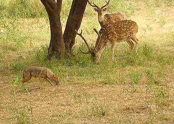
The Jim Corbett National Park in the Nainital district is India's oldest national park. The park, which is 63 km (39 mi) west by north-west of Nainital, contains a wide variety of wild life including elephant, tiger, chital, Sambar Deer, nilgai, gharial, King Cobra, muntjac, wild boar, hedgehog, common musk shrew (White-toothed shrew), flying fox (pteropus, megabat), Indian Pangolin, and nearly 600 species of birds.
Jim Corbett National Park
Mukteshwar (2,286 m (7,500 ft)) is a picturesque town 52 km (32 mi) north-east of Nainital, is home to the Indian Veterinary Research Institute. It also offers an unhindered view of the high mountains of the western Himalaya, including Nanda Devi, Trisul, and Nanda Kot. Bhimtal Lake is named after the second Pandava brother Bhima in the Mahabharata who was known for his prodigious strength.
The lake, which is larger than Naini Lake, is approximately 22 km (14 mi) from Nainital at an altitude of 1,370 m (4,495 ft). There is an island in the lake with a popular restaurant on it. There is also a 17th century temple complex, the Bhimeshwar there. Sattal, literally Seven Lakes, is at a distance of about 23 km (14 mi) from Nainital in the Lower Himalayan Range at an altitude of 1,370 m (4,495 ft). It is a cluster of small interconnected lakes in the midst of an old oak forest. On approaching Sattal, the first lake encountered is the Nal-Damyanti Lake; next it is the Panna or Garude lake; and finally there is a cluster of three lakes: Ram, Laxman, and Sita lakes.
Mukteshwar
Khurpa Tal, literally Trowel Lake, is an attractive lake about 10 km (6 mi) by road (or a 5 km (3 mi) hike) from Nainital at an altitude of 1,635 m (5,364 ft). It is popular with anglers and is surrounded by terraced fields (or farms), from which it presumably gets its name. Naukuchia Tal, literally, Nine-Cornered Lake, is 26 km (16 mi) from Nainital and 4 km from Bhimtal at an altitude of 1,220 m (4,003 ft).
The lake is almost 1 km (1 mi) long, 0.5 km (0.3 mi) wide and approximately 40 m (131 ft) deep. It is the deepest of the lakes in the greater Naintal area. According to legend, if one takes in all nine corners in one glimpse, one can disappear in a cloud of smoke. Hanumangarhi, also known as Hanuman Garh, is located at an altitude 1,951 m (6,401 ft). The temple complex is about 3.5 km (2.2 mi) from the Tallital (South End) bus stop. The presiding deity of the temple is Lord Hanuman, the vanara god of the Ramayana, and he is depicted tearing open his chest to reveal Rama and Sita in his heart. Hanuman Garhi is also known for its spectacular views of the setting sun.
Nearby places around Nainital for sight seeing are Ranikhet, a hill station and cantonment town in Almora district and Bageshwar, a city and a municipal board in Bageshwar district. Kausani is a place situated in the Bageshwar district. Pantnagar Airport is the nearest airport to Nainital.
Nainital
Governor’s House also known Raj Bhavan and formerly, Government House was built in 1899 and designed in the Victorian Gothic domestic style by the architect F.W. Stevens.Earlier a summer residence, it is currently, Raj Bhavan is the official guest house for the governor of Uttarakhand and for visiting state guests. The complex consists of a two-storied mansion with 113 rooms, a large garden, a swimming pool, and golf links. Snow View is situated at an altitude of 2,270 m (7,448 ft) and located atop the Sher-ka-danda Ridge (north by north-east of the town centre), is easily reachable by cable car. On a clear day, it offers spectacular views of the snowbound high Himalaya, including Nanda Devi, Trisul, and Nanda Kot.
Nanda Kot
Naina Peak also known as China Peak is the highest peak in the town, with an altitude of 2,615 m (8,579 ft). and at a walking distance of 6 km (4 mi) from the north end of the town (Mallital). Tiffin Top also known as Dorothy's Seat is terraced hill top (2,292 m (7,520 ft)) on Ayarpatta hill is a 4 km (2 mi) hike from the town centre and commands a nice view of the neighbouring country side.
The Jim Corbett National Park in the Nainital district is India's oldest national park. The park, which is 63 km (39 mi) west by north-west of Nainital, contains a wide variety of wild life including elephant, tiger, chital, Sambar Deer, nilgai, gharial, King Cobra, muntjac, wild boar, hedgehog, common musk shrew (White-toothed shrew), flying fox (pteropus, megabat), Indian Pangolin, and nearly 600 species of birds.
Jim Corbett National Park
Mukteshwar (2,286 m (7,500 ft)) is a picturesque town 52 km (32 mi) north-east of Nainital, is home to the Indian Veterinary Research Institute. It also offers an unhindered view of the high mountains of the western Himalaya, including Nanda Devi, Trisul, and Nanda Kot. Bhimtal Lake is named after the second Pandava brother Bhima in the Mahabharata who was known for his prodigious strength.
The lake, which is larger than Naini Lake, is approximately 22 km (14 mi) from Nainital at an altitude of 1,370 m (4,495 ft). There is an island in the lake with a popular restaurant on it. There is also a 17th century temple complex, the Bhimeshwar there. Sattal, literally Seven Lakes, is at a distance of about 23 km (14 mi) from Nainital in the Lower Himalayan Range at an altitude of 1,370 m (4,495 ft). It is a cluster of small interconnected lakes in the midst of an old oak forest. On approaching Sattal, the first lake encountered is the Nal-Damyanti Lake; next it is the Panna or Garude lake; and finally there is a cluster of three lakes: Ram, Laxman, and Sita lakes.
Mukteshwar
Khurpa Tal, literally Trowel Lake, is an attractive lake about 10 km (6 mi) by road (or a 5 km (3 mi) hike) from Nainital at an altitude of 1,635 m (5,364 ft). It is popular with anglers and is surrounded by terraced fields (or farms), from which it presumably gets its name. Naukuchia Tal, literally, Nine-Cornered Lake, is 26 km (16 mi) from Nainital and 4 km from Bhimtal at an altitude of 1,220 m (4,003 ft).
The lake is almost 1 km (1 mi) long, 0.5 km (0.3 mi) wide and approximately 40 m (131 ft) deep. It is the deepest of the lakes in the greater Naintal area. According to legend, if one takes in all nine corners in one glimpse, one can disappear in a cloud of smoke. Hanumangarhi, also known as Hanuman Garh, is located at an altitude 1,951 m (6,401 ft). The temple complex is about 3.5 km (2.2 mi) from the Tallital (South End) bus stop. The presiding deity of the temple is Lord Hanuman, the vanara god of the Ramayana, and he is depicted tearing open his chest to reveal Rama and Sita in his heart. Hanuman Garhi is also known for its spectacular views of the setting sun.
Nearby places around Nainital for sight seeing are Ranikhet, a hill station and cantonment town in Almora district and Bageshwar, a city and a municipal board in Bageshwar district. Kausani is a place situated in the Bageshwar district. Pantnagar Airport is the nearest airport to Nainital.
No comments:
Post a Comment